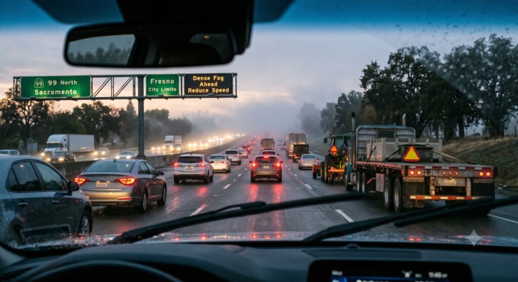
Fresno has a distinct rhythm to daily life that sets it apart from California’s coastal cities. The pace is different, the geography is different, and the relationship residents have with their cars and their commutes reflects a Central Valley lifestyle built around agricultural rhythms, affordable sprawl, and a road network that carries everything from farm equipment to daily commuter traffic. For anyone living in or visiting Fresno, understanding the practical realities of getting around safely is part of enjoying what the city and the broader Valley have to offer.
The Fresno Commute: What Makes It Different
Fresno’s road network reflects the city’s identity as the anchor of California’s agricultural heartland. State Route 99 runs directly through the city, carrying commuter traffic alongside a substantial volume of commercial agricultural transport, and the resulting mix of vehicle types and speeds is something most newcomers need time to adjust to. The San Joaquin Valley, the southern portion of California’s Central Valley in which Fresno sits, remains one of the most productive agricultural regions in the world, and its road network reflects that agricultural economic base as much as it reflects the needs of everyday commuters. Farm equipment moving at a fraction of highway speed shares road space with commuters trying to make it to work on time, and the resulting speed differential is a recurring source of near misses and, occasionally, serious collisions.
Seasonal conditions add another layer that Fresno residents learn to navigate. Winter tule fog can reduce visibility to near zero with little warning, particularly on outlying stretches of Highway 99 and the rural roads connecting Fresno to surrounding agricultural communities. Locals develop an intuitive sense for when fog risk is highest, typically calm, clear winter nights following a period of rain, but visitors and newer residents are often caught off guard.
Popular Fresno Destinations and Getting There Safely
Fresno’s appeal extends well beyond the city itself, and much of the local lifestyle revolves around access to nearby destinations that require navigating Valley roads.
Yosemite National Park sits within reasonable driving distance via Highway 41, a route that climbs from Valley floor to mountain elevation and demands real attention, particularly in winter when snow and ice become factors on the upper elevations even as Fresno itself remains mild. Drivers accustomed to flat Valley roads sometimes underestimate how quickly conditions change on the ascent.
The Sierra National Forest and the foothill communities east of Fresno draw significant recreational traffic on weekends, particularly during summer months when Valley heat pushes residents toward higher, cooler elevations. The two-lane mountain roads serving these areas carry a mix of local traffic, weekend recreational visitors, and, during fire season, emergency and firefighting vehicle traffic that requires drivers to stay alert and yield appropriately.
Closer to home, Fresno’s own growth has reshaped its urban core considerably. The Tower District and downtown Fresno have seen substantial revitalization, bringing increased pedestrian and cyclist activity to areas that were historically car-dominated, a shift that has required drivers throughout the city to adjust to more mixed-use street environments than were typical a decade ago.
Practical Safety Habits for Central Valley Driving
Several practical habits serve Fresno residents and visitors well given the specific driving conditions the region presents.
Building extra time into agricultural corridor trips accounts for slow-moving farm equipment, a reality of Valley life that is not going away and that no amount of impatience will change. Treating a trip along a rural highway during harvest season with the same time buffer as a trip through downtown during rush hour reflects the actual conditions on the ground.
Checking fog conditions before winter evening or early morning drives, particularly on Highway 99 and rural connector roads, can prevent the kind of low-visibility encounters that produce the Valley’s most serious multi-vehicle incidents. Local news stations and the National Weather Service provide fog advisories during peak risk periods, and taking them seriously rather than assuming familiarity with the route is sufficient protection matters.
Maintaining a buffer around agricultural and commercial vehicles, which have different stopping distances, blind spots, and turning radii than passenger vehicles, reduces the risk of the kind of collision that occurs when a driver misjudges how a large vehicle will behave.
When Fresno’s Roads Do Not Cooperate
Even with careful driving habits, Fresno’s specific mix of road conditions, seasonal weather, and vehicle types means that serious crashes remain a reality for the region. When they happen, having a clear understanding of what to do, and who to call, matters.
Fowler | Helsel | Vogt Fresno Injury Attorneys represent injured residents and visitors across Fresno and the broader Central Valley, with particular experience in the kinds of agricultural, commercial vehicle, and fog-related crashes that are distinctive to the region. Their work reflects a practical understanding that Fresno’s roads present challenges that differ meaningfully from what drivers encounter elsewhere in California, and that effective representation requires understanding those specific conditions.
Fresno’s lifestyle, with its access to mountains, foothills, and the broader agricultural landscape that defines the Valley, comes with real rewards for residents who embrace it. Staying safe while doing so is simply part of living well in this part of California, and understanding the specific risks the region presents is the first step toward managing them responsibly.

